fbpx

Recently a friend alerted me to a discussion online about major renovations to be started soon in the vicinity of Jaffa Gate.  Among other things, this will close the gate off to vehicular traffic.  If they dig anything up, chances are very high that they’ll find something of significance, which will slow their progress down even further.  A source in Jerusalem relates the following:

1. The gate is being closed to car traffic due to road renovations.

2. They may leave one lane open for one-way traffic.

3. The gate is supposed to close soon after Succot (which ended a few days ago).

4. A Muslim policeman “who isn’t trustworthy” said that the gate would NOT reopen ever.

5. Shop owners are concerned about how they will receive supplies.

This is not the first time the authorities have done major work on the road here.
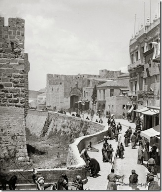
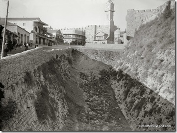
View inside Jaffa Gate, mat04928 Jaffa Gate area from east, with Crusader moat of Citadel visible in foreground.  Date of photograph: 1898-1907.  From the new Jerusalem CD.
Share:

Understanding the ancient Pool(s) of Siloam is a bit difficult.  First, there is the pool where Hezekiah’s Tunnel emerges.  This pool is small, shallow, and unimpressive.  In 2004, a monumental reservoir was discovered to the south, dating to the 1st century A.D. (for more on that, see here and here).

Scholars today do not yet know how the two pools are related.  The Lower Pool was quite likely the place of the miracle of the healing of the blind man (John 9).  The area above was the site of a pool in the Late Roman period, and continued in use in the Byzantine period when a 5th century church was constructed over it.  What existed here before the destruction of Jerusalem in A.D. 70 is not known.

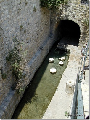
Pool of Siloam, tb051501204

Pool of Siloam, view to the north, present day

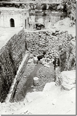
Today if you visit the pool at the end of Hezekiah’s Tunnel, there are a few column drums from the Byzantine pool, but little else to suggest the beautiful complex that pilgrims visited.  That hasn’t always been the case, however, for the excavations of Bliss and Dickie in the 1890s revealed some of the ancient walls.  In the photo below, behind the donkey is a wall of large, well-dressed stones with a classical molding.  The excavators identified this as the northern side of the square Roman pool.

Pool of Siloam, north end, mat08471 Pool of Siloam, view to the north, early 1900s

After the excavations, Muslims erected a mosque over the northwestern corner of the area, covering all traces of the earlier pool and the Byzantine church built to commemorate it. 

This photograph is one of 45 in the “City of David” set included in the Jerusalem volume of The American Colony and Eric Matson Collection.  Photo: Library of Congress, LC-matpc-08471.

Share:

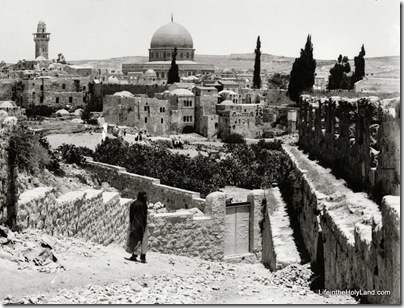
Temple Mount and Western Wall area from southwest, mat00886

This photograph was taken by the American Colony photographers between 1900 and 1920 from the southern wall of the Old City (visible on the right edge).  The Dome of the Rock is clearly visible, but you have to look harder to see a portion of the Western Wall below it.  The buildings directly below the Dome are in the area of today’s “ramp” giving access to the Temple Mount to non-Muslims.  The fields in the foreground are cactus.

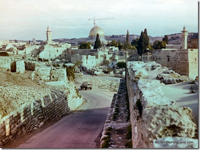
Old City southern wall with Dome of the Rock, db6401192102

By 1964, the plants had been removed and a narrow road paved.  The road today follows a circuitous route similar to that shown here, where buses pick up passengers from the Western Wall.

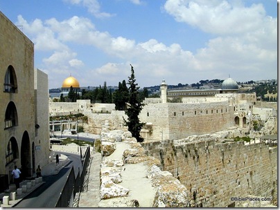
Dome of Rock and Al Aqsa from southwest, tb051501801
The problem today is that you can’t get the same perspective because of buildings in the way. 

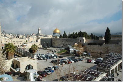
Western Wall and Dome of Rock from southwest, tb122604408
You get a better feel for the comparison if you move in front of the buildings. 

If it’s easier for you to compare these if you have them in a larger size in a PowerPoint file, you can download that here (but see update below).

The first photo is one of 77 photographs in the “Views of Jerusalem” section of the Jerusalem volume of The American Colony and Eric Matson Collection.  Photo: Library of Congress, LC-matpc-00886. 

The second photo is from Views That Have Vanished: The Photographs of David Bivin.

UPDATE (9/23): Mark V. Hoffman has edited the PowerPoint file so that the images are aligned and transition smoothly one to the next.  You can download that here.  Thanks Mark!

Share:

Jerusalem, looking down moat toward clock tower, mat08549

Jaffa Gate vicinity from southwest, 1907-1920

I cannot locate a “today” version from this perspective, but you can just imagine the changes:

1) the Crusader moat in the foreground has been completely filled in;

2) the shops on the left side of the photo have been torn down;

3) the clock tower has been dismantled;

4) the fountain has been removed.  Other than that, it looks pretty much the same today.


If a reader has a photo from this perspective that they want to share, feel free to send it to me and I will post it here.  I’ve walked this way many times, but I guess I just considered it too ordinary to photograph. It was 19 years ago that I walked this way on my first date with (now) wife.

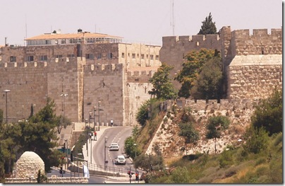
Jaffa Gate, by Menachem Brody Jaffa Gate, present day.  Photo by Menachem Brody.

This photograph is from the newly released Jerusalem CD, volume 2 of The American Colony and Eric Matson Collection. The collection includes 685 photographs, including 26 in the Jaffa Gate set, revealing the dramatic changes in this area from 1898 to 1946. Photo: Library of Congress, LC-matpc-08549.

Share:

General Charles Gordon was a well-known British leader when he came to live near Jerusalem in 1882, often visiting the home of Horatio and Anna Spafford, founders of the American Colony.  From their quarters atop the northern wall of the Old City, Gordon had a view of a rocky escarpment in which he identified the features of a skull.  He identified this location as the “Place of the Skull” (Aramaic: Golgotha; Latin: Calvary).  Around the corner was an ancient tomb which he believed was the empty tomb of Christ.  A decade later, the property was purchased by a concerned group of Christians in England and the Garden Tomb Association was formed.

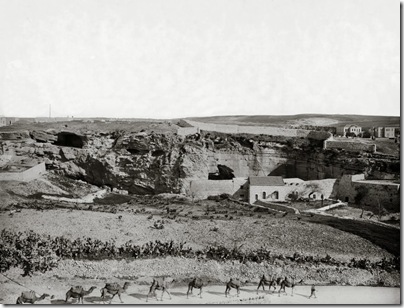
Gordon's Calvary, mat06666 The area known as “Gordon’s Calvary,” early 1900s

In this photo, taken between 1898 and 1914, the view is similar to the one that Gordon had from the American Colony home.  The caves that form the eye sockets of the skull are visible just left of center.  The tomb is out of view behind the wall on the left side.  On the top of the hill some tombs of the Muslim cemetery can be seen.  The camels are walking east along what is today a busy four-lane street.

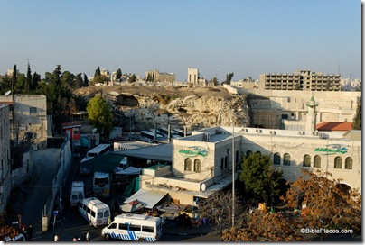
The photo below was taken in 2006 and the most prominent feature is the bus station.  The two “eye sockets” are visible, but most of the rest of the landscape is covered.  If you believe that Jesus was crucified in this area, you’ll do better using the black and white photo to visualize the event.

Gordon's Calvary from south, tb122006023 The area known as “Gordon’s Calvary,” present day

Concerning the tomb’s authenticity, Robert Alexander Stewart Macalister wrote in 1907:

It is a pity that so much is claimed for [this tomb]; the prejudice raised thereby is apt to blind one to the fact that it is a remarkably interesting sepulchre. . . . In conversation with tourists at the hotel in Jerusalem I constantly hear such a remark as this: ‘I came to Jerusalem fully convinced that the Church of the Holy Sepulchre was the true site; but I went to the Church and saw all the “mummery” that goes on there, and I saw the Muhammadan soldiers guarding the place to prevent the Christians fighting. Then I went to that peaceful garden: and then I knew that the church was wrong, and that Gordon had found the real site.’ This is the most convincing argument that can be advanced in favor of the tomb, and it is obviously quite unanswerable (Palestine Exploration Quarterly, 1907, p. 232).

The top photo is one 15 photographs in a presentation of the Garden Tomb in the newly released Jerusalem CD, volume 2 of The American Colony and Eric Matson Collection. The presentation includes a carefully researched history of the area.  Photo: Library of Congress, LC-matpc-06666.

Share:

One of my favorite places in Israel is not visited by most tourists.  (Come to think of it, that’s true of most of my favorite places.)  I like tells and I love panoramic vistas.  But I also love to sit back, put my feet in the Sea of Galilee, and relax.  Give me a book or give my kids a raft and it’s all the better.  I’ve probably watched the sun set over the Sea of Galilee from here more than 200 times.

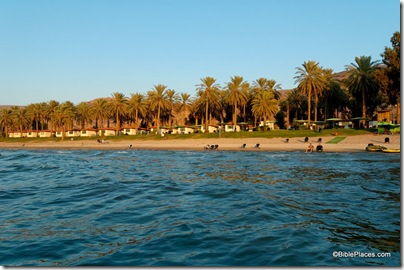
En Gev holiday village from Sea of Galilee, tb101105949ddd En Gev Holiday Village

The place is En Gev, and it hasn’t always been a beautiful holiday resort.  In biblical times, people were settled on the tell in the middle of today’s kibbutz.  Some have identified it as “Lower Aphek.” 

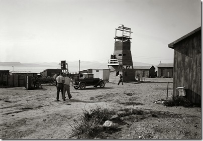
In the 1930s, courageous Jewish pioneers settled this uninhabited area with a “tower and stockade.” 

The compound became a kibbutz, and from 1948 to 1967 residents lived below the Syrian-controlled mountains of the Golan Heights.  Shelling was frequent and bomb shelters became bedrooms.  Since 1967, Israel has controlled the Golan Heights and Kibbutz En Gev has developed a flourishing tourist industry, including the holiday village, tourist boats, and fish restaurant. 

Ein Gev lookout tower with sea beyond, mat03684

En Gev settlement with watchtower. Date of photograph: 1934-39

As you drive along the eastern shore of the Sea of Galilee today, there is relatively little development.  One reason for that is the hostile conditions until 1967 and the uncertainty since then of the Golan Heights’ future. 

The second photograph is one of 600 high-resolution images in the newly released Northern Palestine CD, volume 1 of The American Colony and Eric Matson Collection. Photo: Library of Congress, LC-matpc-03684.

Share: